


Drone Aerial Land Surveys and Maps


Welcome to Vantage Imagery Limited, your premier destination for Drone Aerial Land Surveys and Maps. Harnessing the power of advanced drone Mavic DJI Drones, we provide comprehensive aerial surveys and drone mapping services tailored to your specific needs. Whether you're in construction, agriculture, real estate, or environmental management, our expertise and cutting-edge equipment ensure precise and accurate results every time.
At Vantage Imagery Limited, we understand the importance of detailed land surveys and maps in informing critical decision-making processes. Our drones capture high-resolution imagery from above, allowing us to create detailed maps, contour lines, and 3D models of your site. From identifying potential hazards and planning construction projects to monitoring crop health and optimizing land use, our aerial surveys offer invaluable insights to drive your success.
With a focus on data accuracy and efficiency, our team of experienced professionals utilises the latest Mavic DJI Drones and advanced software to deliver superior results. Whether you need to measure distances, calculate volumes, or monitor changes over time, our aerial surveys provide the actionable intelligence you need to stay ahead of the curve.
The drone mapping process can produce a 2D/3D georeferenced map or a point cloud.
This is fully interactive, measurements can easily be made directly onto the map, measuring distance, area and gradient.
Topographical Survey

CAD or Dxf files can be overlayed onto your map
Irrigation System

Add separate overlays or view them at the same time for more detail
Digital surface model

DSM with the Topographical survey overlay
Plant Health

The use of multi-spectral light not seen with the human eye to assess the plants health, in this case grass. Easily see any issues that need attention.
Click the link below to Try all of the features available on a 2D and 3D map.
Zoom in, measure an area, distance or elevation. Click on and off the saved annotations and overlay the plant health, irrigation system or topographic survey.
Making maps that work for you
-

Measure it
Use a range of annotations to measure areas, distances or elevation across your entire map.
-
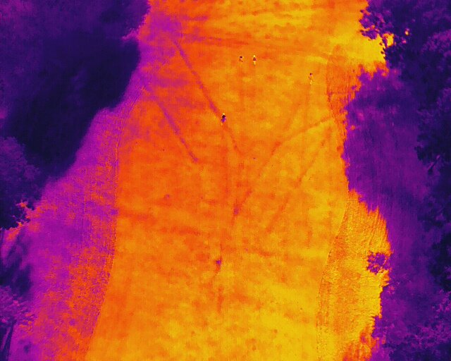
Thermal Imaging
Overlay different types of imagery.
From thermal to plant health index. Helping to identify underground drainage and the efficiency of your irrigation system.
-

Multispectral
This can be used to check a plant or crops health using the plant health index (VARI & TGI)
-

Golf Course
Fully interactive map.
This is a Permanent map for the golf club
Zoom in to see the high resolution 2D or 3D map. (Accurate to sub 3cms)
Add overlays like Irrigation systems and measure areas or distance with ease.
Create your own map.
Invaluable for producing winter program's and working out costing for planned work.
Add drainage maps as its installed
Check out the example 2D/3D map link below!
Survey Equipment
GNSS Base and Rover for RTK
RTK (Real Time Kinematics) are used to produce a highly accurate
(sub 3cm) georeferenced map/point cloud/3D model.
Ideal for building/construction sites, Cut and Fill projects or Plotting areas or Irrigation systems.
RTK & PPK Drones
DJI Phantom 4 Pro equipped with Dual band PPK receiver from Topodrone and a 20 megapixel camera which uses a mechanical shutter.
Both combined make it perfect for producing highly accurate georeferenced Maps or Drone Surveys.

GNSS Rover
This is one of 2 we use in RTK (Real Time Kinematics) or using NTRIP services. To collect GCP’s (ground control points) and check points to add to the maps accuracy.

DISCLAIMER
Vantage Imagery Ltd is NOT a survey company and it does not claim to be accredited surveyors or geomatics specialists.
Provided geospatial products would typically fall within the potential accuracy range as indicated within the 'RICS Professional Guidance Note - Measured Surveys of Land, Buildings and Utilities (Bands D to E)' and, therefore, must not be further used beyond its tasked-for requirements and /or to support other projects that would require greater degrees of accuracies."
Our geospatial products SHOULD NOT be independently used to authenticate measurements of any kind and be used in any legally-binding documentation UNLESS they have been ortho-rectified and are accompanied with additional and authenticated positional geodetic information that has been provided by a trained/accredited party accompanied by accuracy statements and which would compliment other accurate and project-supporting geospatial-related data.
Exploring the 5 Best Drones for Drone Mapping
Aerial Surveying Takes Flight
In today's rapidly evolving world, drones have emerged as indispensable tools for various industries, and one of the most promising applications is land mapping. These drones, equipped with advanced technology, have revolutionized the way we survey and map landscapes, delivering precise data and imagery for a multitude of purposes, from urban planning to agriculture. In this article, we'll introduce you to the top 5 drones for mapping, each renowned for its exceptional capabilities and specifications.
DJI Phantom 4 RTK
DJI, a household name in the drone industry, offers the Phantom 4 RTK, a high-precision drone mapping solution that excels in accuracy and efficiency. This drone boasts a built-in RTK (Real-Time Kinematic) module, which provides centimeter-level positioning accuracy. It also features a 1-inch, 20-megapixel camera with a mechanical shutter for sharp, distortion-free aerial imagery. The Phantom 4 RTK can cover up to 2.2 square miles in a single flight and can fly for approximately 30 minutes on a single charge. Its ability to create accurate 3D maps and models makes it a favorite among surveyors and drone mapping professionals.
SenseFly eBee X
For those seeking a versatile mapping drone, the *senseFly eBee X* is an excellent choice. Designed for professional surveying and drone mapping, the eBee X offers various camera options, including RGB, multispectral, and thermal. It can cover up to 500 acres in a single flight, thanks to its impressive endurance of up to 90 minutes. This fixed-wing drone is also known for its robust performance in challenging weather conditions, making it a reliable tool for large-scale drone mapping projects.
Parrot Anafi USA
*Parrot Anafi USA* stands out as a compact and rugged drone, perfect for drone mapping in tough environments. With a 32x zoom camera, it can capture detailed imagery even from a distance. The Anafi USA is equipped with thermal imaging capabilities, making it an ideal choice for applications like search and rescue, in addition to land mapping. It offers a flight time of up to 32 minutes and can withstand winds of up to 31 mph, ensuring reliable performance in various conditions.
Yuneec H520
The *Yuneec H520* is a versatile hexacopter designed for professional mapping and surveying tasks. It supports a range of cameras, including the E90, E50, and E30Z, allowing users to choose the best option for their specific needs. The H520 offers up to 28 minutes of flight time and features obstacle avoidance technology for safe and precise flight. With its adaptable payload options and reliability, it has become a popular choice among drone mapping professionals.
DJI Mavic 3E
The Mavic 3 Enterprise Series redefines industry standards for small commercial drones. With a mechanical shutter, a 56× zoom camera, and an RTK module for centimeter-level precision, the Mavic 3E brings drone mapping and mission efficiency to new heights. A thermal version is available for firefighting, search and rescue, inspection, and night operations.
Streamlined and compact, Mavic 3 Enterprise Series can be carried in one hand and deployed at a moment's notice. Perfect for beginner and veteran pilots alike, it's built to perform on lengthy missions.
Mavic 3E's wide-angle 4/3 CMOS, 20MP sensor has a mechanical shutter to prevent motion blur and supports rapid 0.7-second interval shooting. Complete drone mapping missions with extraordinary efficiency without the need for Ground Control Points but they are still recommended.